Portofino Map: The Promontory, the Harbours and Every Start
Hours, prices and access verified by the Portofino Tours team — last checked 2026-09-28.
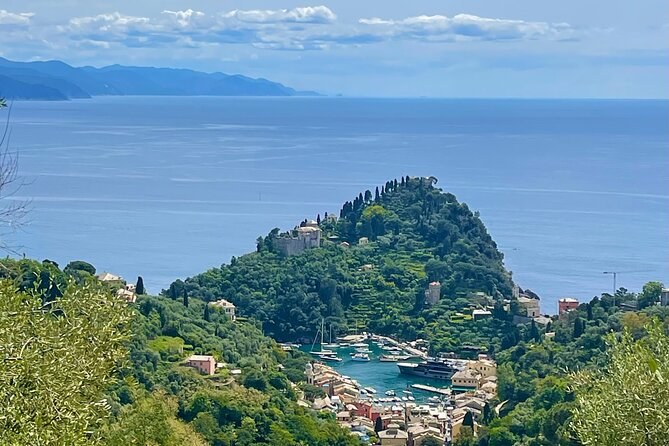
On a map Portofino is a small harbour at the tip of a green headland. Before you buy
Portofino tickets for a trip, find where it starts. It may be the village, a pier across the
gulf, a bay before the village or a quay in Genoa.
The coast from west to east
The promontory juts south into the sea between Genoa and the Gulf of Tigullio. Camogli sits on
its western side, and Santa Margherita and Rapallo on the eastern. Portofino sits in a small bay
near the tip.
Genoa
The city to the west, with the cruise terminal and Porto Antico. A car takes about an hour to Portofino, one private walk's listing says.
Camogli
The town on the western side of the promontory. Its boats sail to San Fruttuoso all year.
Punta Chiappa
A point on the Camogli side of the promontory. Boats stop off it to swim.
San Fruttuoso
The bay with no road, on the south side, with the abbey and the statue offshore.
The lighthouse
The white light on the tip of the headland, past the Olivetta. Boats and the kayak go round it.
Portofino
The village round its narrow harbour, with the Piazzetta at the top.
Paraggi
The small bay a kilometre before the village, with the kayak base at Niasca.
Santa Margherita Ligure
The town with the station, the ferry pier and the long seafront.
Rapallo
The town further along the gulf, with the motorway exit and several boarding points.
The village itself: harbour, square, church and castle
Portofino is compact. The quays run round the harbour, and the Piazzetta opens at its head.
From the harbour, Salita San Giorgio climbs to the church on the cliff.
The castle stands above the harbour, reached from Via alla Penisola or from its park. A path
leads on toward the lighthouse, and painted tiles on a wall point you the way. Things to do covers each sight, with its hours.
Round the headland by boat
The classic boat run shows you the promontory in order. The small-group boat from Portofino
harbour spends ten minutes off the lighthouse. Then it crosses the bay of the underwater statue
and stops in the bay of San Fruttuoso.
After a swim stop it passes Punta Chiappa and reaches Camogli, then turns back. That is the
whole south side of the park, seen from the water in two and a half hours.
Boats from Rapallo start on the gulf side. They pass Santa Margherita or Paraggi before they
reach Portofino.
Further along the gulf: Chiavari, Sestri Levante and the Cinque Terre
East of Rapallo the shore runs on to Chiavari, Lavagna and Sestri Levante. Ferry line 2 links
them to Portofino and San Fruttuoso, and line 5 runs from them to the Cinque Terre all day.
The Cinque Terre lie further south-east, past Sestri Levante. From Santa Margherita or Rapallo,
line 4 spends 3 hours ashore in Monterosso and 1 in Riomaggiore. One private boat also sails
there for the day.
The harbours, and which boats use them
Most trips on the water start in one of three towns: Portofino, Santa Margherita or Rapallo.
The public ferries link all three, and continue round the headland to San Fruttuoso.
From Camogli, a different company sails to San Fruttuoso all year. From Genoa, boats come east
along the coast in season.
The protected sea round the headland
The sea round the promontory is a marine protected area, split into zones A, B and C. It
touches three comuni: Camogli, Portofino and Santa Margherita.
On the western side, boats may not anchor over the seagrass from the Cenobio dei Dogi to
Camogli's Tonnarella. Your skipper knows the lines.
A wooded headland and a small harbour below it, the open sea beyond
The park on the land
Above the sea, the Parco di Portofino covers the headland, with 80 km of trails. The trail from
Portofino to San Fruttuoso runs along the south side.
From Santa Margherita, a gentler route climbs past Nozarego and the Mulino del Gassetta to the
village. Activities gives each route's grade and time.
Where each trip starts
The trip
Where you meet
Town
Small-group boat
Molo Umberto I, outside Ristorante Cracco
Portofino
Private boats
Molo Umberto I, or opposite Ristorante Stella
Portofino
Private walks
The Piazzetta, or the Molo Isolotto tender pier
Portofino
Kayak and paddleboard
The Niasca base, Via Duca degli Abruzzi 62
Paraggi
Pesto walk
Piazza Martiri della Libertà, by the ferry pier
Santa Margherita Ligure
Private boats and walks
Molo Maloncello, or Piazza Vittorio Veneto 1
Santa Margherita Ligure
Small-group and private boats
Rotonda Marconi, by the river bridge
Rapallo
Private boats
The Andrea Doria pier, or pier F12 at Porto Carlo Riva
Rapallo
Private hike
Your hotel
Santa Margherita, Camogli or Portofino
Day boat
Porto Antico, Molo Ponte Morosini 1
Genoa
Bus and boat day
Via Fanti d'Italia, by the cruise terminal
Genoa
Your booking gives the exact pier, and a boat may change it with the sea. Check it the evening
before. Getting there shows how to reach each town.
Map of Portofino and the gulf
Portofino, Liguria, Italy
The promontory, from Camogli to Rapallo
The map loads from Google only when you press the button. Zoom in to find the harbour, Paraggi
and the bay of San Fruttuoso.
Found your start?
Boats from three harbours, the kayak from Paraggi, and days from Genoa.
On the tip of a promontory on the Italian Riviera, east of Genoa, in Liguria. It faces the Gulf of Tigullio, with Santa Margherita and Rapallo along the shore. Camogli lies on the other side of the headland.
How far is San Fruttuoso from Portofino?
It is the next bay west, round the headland. The ferry runs between them in season. On foot, the park's guided hike took 2 hours 30.
Where do the Portofino boats leave from?
From Portofino harbour, from Santa Margherita's ferry pier and Molo Maloncello, and from three piers in Rapallo. One day boat sails from Porto Antico in Genoa.
Is there a map of the park's trails?
The park publishes its trails and restored sites on its own website. Check its notices before a walk, because paths close after storms.
Where these facts come from
The marine area and its zones are its own page, and the park is its own site, checked 28 September 2026. The
ferry lines are the consortium's. Every meeting point comes from that trip's own listing.
Four hours from Rapallo on a shared boat of up to 12: an hour ashore in Portofino, an hour snorkelling in San Fruttuoso bay and a stop at Paraggi. Fuel and snorkel gear are in the fare.
Three to four hours on a private boat from Santa Margherita or Rapallo: Portofino harbour, ashore if you ask, round the lighthouse and a swim at San Fruttuoso. Towels and a toilet on board.
A full day on your own boat from Genoa's old harbour: about an hour and a half ashore each at San Fruttuoso, Portofino and Camogli, with two swim stops.